

You are here: NazcaFlights.com > Introduction
The following brief introduction to Nazca and the Nazca Lines comes from Archaelogy Expert, Inc. We offer flights over the Nazca Lines, and also flights over the Palpa Lines, and the aqueducts of Cantalloc.

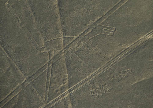
(Above Photo: The Dog, one of the famous Nazca Lines geoglyphs)
What and Where is Nazca?
Nazca is a small city in Peru some 200 miles south of Lima on the Pacific coast. In the Peruvian desert near the city, there is an extensive plain between the Inca and Nazca valleys. This huge, flat pampa is the site of the world-famous Nazca Lines. Tourism is the main source of revenue for the city, and there are dozens of hotels, hostals, restaurants, etc that cater to the visitors.
The Ancient Nazca Culture
Nazca has also come to mean the cultural group or even the civilisation
that flourished in this Peruvian district for about 1100 years from
300 BC to AD 800. It was during this period that the famous Nazca Lines
were constructed along with impressive subterranean aqueducts that are
still used today for the conveyance of water.
Discovering the Lines
Criss-crossed all over the 37 mile long plain at Nazca are an assortment
of geometrically straight lines, some running parallel, others crossing
over and intersecting other lines. This outstanding geometric ground
form remained undiscovered until the early 1930s when it was noticed
by the first aerial flights over the area during aerial survey work
to locate water sources.
The Nazca lines are an attractive and amazing feature. Not only are there perfectly straight lines criss-crossing all over the plain like giant, elaborate, airport landing runways, but there are trapezoidal zones, pictures and animals, such as birds and beasts, as well as indistinguishable symbols.
The remarkable aspect of these creations of the Nazca culture is that they can only be recognised from high in the air. For more than one thousand years since the Nazca people ceased their cultural ways the desert plain has been walked over from north to south by its inhabitants yet the secrets of the lines and symbols have all remained silently underfoot, unnoticed from ground level.
What are the Lines? They are Archaeological Geoglyphs
These large drawings on the surface of the earth are known as geoglyphs
but they make no sense at all to those who view them from the ground.
Aerial archaeology, involving aerial photography and mapping, has brought
the recognition of several kinds of animal figures – monkeys,
birds, fish – even a whale, as well as insect forms such as spiders
and a variety of plants. Aerial observation has shown that the lines
continue along the ground for more than 800 miles.
What Was Their Purpose?
The science fiction writer, Erich von Daniken suggested that they were
landing strips for alien spacecraft. However, the geology of the desert
floor cannot support this [fairly stupid] theory, as it is soft earth
unable to accept the fast moving weight of any sizeable aircraft.
Like so many unusual structures of antiquity they are often attributed as being astronomically significant. However, an American astronomer, Gerald Hawkins, debunked this theory by using computer probability analysis to see if the lines matched any ancient astronomical event or coincided with major celestial elements. His conclusions found that the lines demonstrated no distinct patterning to the cosmos.
Using experimental archaeology the British explorer, Tony Morrison, observed that the old folk customs of the Andes Mountain people demonstrated an unusual and pertinent tradition. His research discovered that the mountain people would travel from shrine to shrine in direct straight paths praying as they walked. A straight, direct path, similar to the patterns found at Nazca, linked each shrine, which could be nothing more than a carefully grouped pile of stones or more elaborate structures. Morrison has concluded that the Nazca lines could have been used during religious or ceremonial occasions.
The Lines Were a Community Project
The Nazca lines and the animal, insect, and human geoglyphs formed in
the red soils of the Pampa Colorada is a project that required a great
number of people, although not necessarily highly trained, as the work
could be undertaken using simple tools. However, the extent of the project
is such that there can be little doubt as to it being a communal undertaking
and possibly took many years to achieve.
No one will really know if this magnificent site was the religious ‘Jerusalem’ of the Nazca. It has become an important archaeological discovery that is shared with thousands of visitors annually. The best view of archaeological Nazca is still from far above the site in an aeroplane.


Legal Disclaimer and Copyright Notice
copyright © 2009 by NazcaFlights.com - your best source for flights over the Nazca Lines, tours of of the pre-Incan Chauchilla cemetery, the aquaducts of Cantayoc, the citadel Cahuachi, and the world's biggest sand dune: Cerro Blanco